ENVIRONMENTAL CONSULTANT
- Delegate to the IUCN World Parks Congress, contributing to marine protected area policy.
- International experience throughout Asia, Micronesia, Australia, Europe and North America.
- Awarded $20,000 in funding to design a constructed wetland to treat storm water runoff in the CNMI.
- Developed outreach and education materials, brochures and presentations for natural resource protection and coral reef conservation for non-profit organizations in Washington, DC, Pittsburgh, PA and Florida.
- Promoted low-impact SCUBA diving through exhibits and educational material to enhance awareness.
- Provided regulatory guidance for a wastewater treatment wetland at a new USFWS coastal visitor center.
- Authored a long-term stewardship and conservation management plan for a unique property containing rare flora and historic resources. The property was donated to a non-profit trust for public use and enjoyment.
- Developed sustainable coastal land use planning alternatives with stakeholder and Indigenous participation.
CURRENT PLANNING ACTIVITIES
Shoreline Area Planning August 2004 – current
As an employee of Maui County, I participate in shoreline setback assessments and determine if the setback has been correctly calculated based on annual erosion hazard rate and/or average lot depth, as applicable. I utilize GIS files and aerial photographs to determine the applicability of the rules to the proposed activity or property using tax map keys (TMK), application, and KIVA database information. I communicate the intent, nature, substance and particulars of the Shoreline Rules to the public and general contractors / consultants upon request. In addition, I recommend prudent site plan alterations to minimize, avoid or mitigate impacts to property from coastal hazards and erosion. I am responsible for providing recommendations for approval of shoreline setback determinations and/or approvals of permitted structures within the shoreline area. Subsequently, I draft correspondence and manage projects to completion relative to shoreline rules. Upon request, I also assist and provide various commissions and decision-making groups with information necessary to make sound decisions, offer testimony when called upon, and attend public meetings and other public forums.
Special Management Area Planning August 2004 – current
As an employee of Maui County, I participate in special management area permit assessments to determine if the proposed structure or activity is a major, minor, emergency or exempt activity. Each application is reviewed relative to various criteria as stated in the Coastal Zone Management Act to ensure long term protection and conservation of coastal resources, ensure public access and views, protect historic artifacts, and reduce vulnerability to coastal hazards, among others. I communicate the intent, nature, substance and particulars of the SMA Rules to the public and general contractors / consultants upon request. Furthermore, I recommend prudent site plan alterations to minimize, avoid or mitigate negative impacts to coastal, natural and environmental resources. I use GIS, as well as aerial photographs to determine the applicability of the rules and criteria to the proposed activity or property using TMK, application, and KIVA information. I review the permit for completeness, determine which agencies should receive a transmittal of the application so that they may comment and/or recommend conditions for sustainable development of coastal, natural and environmental resources. Furthermore, I incorporate conditions and agency comment, verify Community Plan recommendations, and track and manage the project through the public hearing (if applicable) process. Upon request, I also assist and provide various commissions and decision-making groups with information necessary to make sound decisions, offer testimony when called upon, and attend public meetings and other public forums. I am tasked with providing recommendations for approval, approval with conditions, or denial of the issuance of a permit to conduct the proposed development or activity in the Special Management Area based on sound science and policy, concurrent planning of infrastructure, zoning and land use designations, and other community, environmental, coastal, land use policies and considerations.
PROJECTS IN SAIPAN & GUAM
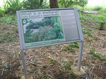
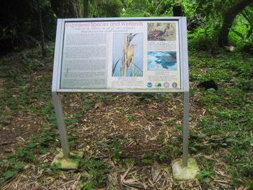
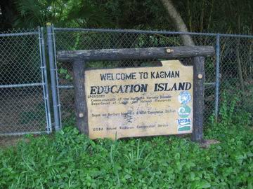
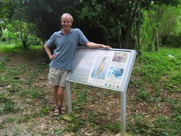
Multi-lingual, Culturally-relevant, Wetland Education Signs May 2004 – June 2006
Contracted by the RC&D of the NRCS in Saipan, I designed four (4) high quality interpretive wetland signs for the Kagman Wetland. The multi-lingual signs target the student audience located at the adjacent Kagman Highschool. The four signs: “What is a Wetland”, “Wetland Functions”, “Endangered Species and Wetlands”, and “Wetlands in the Landscape” (linkages) focus on understanding the importance of wetlands in the community. I was responsible for text, high resolution graphics, the integration of photographs of native wildlife, and the use of local language names to reinforce the importance of protecting this unique habitat and ecosystem function for the future. Contributions from Joseph Ruak, and wildlife photographers Scott Vogt and Kris Wall-Abbott have created exceptional high quality pictures for the public to learn and enjoy about the importance of wetlands in the island’s environment.


Community-based Natural Reserve Zoning Sept. 2003 – June 2004
Enforcement personnel and the public require clear, concise and consistent regulations of prohibited and permitted activities within protected areas. The objective of this project was to develop rules and regulations for all wildlife and marine conservation areas and sanctuaries including land, sea and coastal locations while being consistent between and among them in light of different enabling laws, penalties and ‘takings’ prohibitions. Using laminated maps and markers, stakeholders including community and village leaders, small and large business interests, fishermen, marine sports operators, tourists and tour companies, recreational interests, and members of the public described where and what activities they conducted in protected areas. Through one-on-one and community-based discussions the variety of stakeholders needs and interests were mapped, compiled and analyzed. GIS shape files were created for each protected area based on topographic maps and areas of trade-off’s or mutually beneficial exclusions were determined. Maps and site descriptions were developed that delineated each protected area in various zones including active use, passive use, no take, limited take, restoration, and restricted entry. Rules and regulations were drafted based on statutory empowerment and use zones, incorporating ecologically compatible and incompatible activities. Penalty and Use matrixes were also developed to facilitate the publics understanding of permitted and prohibited activities (and their costs) and to help enforcement officers’ in determining the correct penalty for various violations.
Watershed Management and Infrastructure Planning February 2003 – July 2004
As recipient of a U.S. EPA 319 grant, BEACH Ramp is a highly visible public demonstration of best management practices to reduce runoff into near shore beach areas and treat storm water onsite. As a sub-consultant to the project, I designed a multiple-cell, sub-surface flow, constructed wetland to serve as one of the projects BMPs. Landscape design facilitated the use of native species to treat storm water onsite while reducing public health risks from shoreline discharges during rain events. Design parameters were based on rain gauge data, flow charts, and other pertinent information. As a sub-consultant, I participated in the initial BEACH Ramp public kick-off meeting held last year and have conducted follow-on meetings with landowners adjacent to the wetland project site. Design incorporated discussions with various agency staff such as public works and historic preservation. Educational signage in development will enhance public understanding of coastal wetland functions and offer guidance on replicating the BMP in future coastal development. I successfully secured an additional $20,000 in funding for the BMP, as well as in-kind commitments for service from public agencies and a local non-profit organization. Site construction, to be handled by the lead contractor, is expected to be complete at the end of the year.
Planning Sustainable FisheriesOctober 2003
Conducted an analysis of fisheries laws and synthesized the information for presentation and discussion at the first Pacific Fisheries Workshop held in Guam. Commercial, recreational and subsistence fishermen from Saipan, Rota, Tinian and Guam were provided support and materials to participate in the three day workshop. The objective was to gain insight and advice from these true stakeholders about the best ways to maintain, sustain and regulate fishing within the region. I assisted the agency both in their presentations and at the workshop and attendant meetings. The success of the workshop reflects the importance of gaining the input and insight of un-empowered and/or less vocal stakeholders involved in the decision-making process.
Community Outreach and Information ServicesOctober 2003 – March 2004
Designed, authored content, and created a website for the Division of Fish & Wildlife www.dfw.gov.mp. The website describes native and endangered species, offers downloadable materials such as permit applications, maps of protected areas, teacher packets and educational materials, informative brochures and presentations about the agencies services and mandates. Rules and regulations, boat ramp and fish aggregating device locations, marina rules, fishing and hunting rules and licenses, and staff contacts are available from the site. Site its inception in November, over 1000 visitors a month have downloaded hundred’s of brochures and applications saving both the public and the agency valuable time and energy in a convenient environment. In March, the site was recognized by NOAA’s coastal services center for excellence, top-listed and cross-linked to the center’s domain and search engines.
Marine Conservation PlanningJune 2002 – July 2003
In an effort to plan, manage and conserve marine resources, NOAA created a protected area database website (www.mpa.gov) that inventories all marine protected areas of the United States. I authored a full inventory of the Commonwealth’s marine conservation areas, marine sanctuaries, and marine managed areas for the Department of Lands & Natural Resources Division of Fish & Wildlife and NOAA. Protected area site information, GIS shape files, and map development necessitated frequent communication with stakeholders such as government officials, park concessionaires, marine sports operators and fishermen in one-to-one and small meeting and community-based formats. The national initiative provides critical information and benchmarks for national and local planners, managers, practitioners and policy-makers relative to coral reef protection and marine conservation. The website also serves as a leading education and public outreach tool for protected area site planning. The project received national recognition as lead story on in NOAA’s COASTLINES quarterly magazine for being the first State or Territory to complete its inventory.
Coastal Planning & ManagementSept. 2002 – Sept. 2003
This projects objective was to develop a decision-making tool using specific indicators that would accurately gauge conservation planning and management success for use by planners, practitioners, policy makers and funding agencies. At the invitation of the World Wildlife Fund and International Union of Conservation Nations, I evaluated a series of governance indicators for their applicability and usefulness in determining effective management and site planning of marine conservation areas and sanctuaries. Serving as one of 23 test sites in the world, the project began with a weeklong workshop in Hawaii where I and other practitioners chose socio-economic, biophysical and governance indicators for site evaluation. Discussions with the regulated community, regulators, managers, attorneys, and policy makers provided additional insight into coastal conservation planning in Saipan. The project culminated with the IUCN’s publication of Marine Protected Area Management Effectiveness Indicators, which includes direct excerpts from my analysis, as well as nomination as an official Delegate for the United States to the World Congress held each decade.
PREVIOUS PROJECTS
Natural Reserve Planning and Management
I co-authored an USFWS-approved adaptive management plan for a Species Mitigation Bank. The wildlife sanctuary provides off-site mitigation for ‘takings’ of Nightingale Reed-warblers, a federally listed endangered species. The work was highlighted at the 6th Mitigation Banking Conference held in San Diego last year. In addition, I served as a “Local Navigator” for public meetings regarding the Coral Reef Initiative, facilitating communication and input through Charettes and small-group discussions pertaining to recreational use of coral reef and marine resources. The forums included marine sports operators, dive operators, private individuals and researchers. Results of the meetings formed the basis for development of “Local Action Strategies” to address recreational overuse of coastal resources. Our strategies were then used to develop grant funding opportunities. I was actively involved in all aspects of the community-based planning effort from development of presentations, outreach and education materials, strategic planning, compilation and analysis of the results, grant writing, expenditure and reporting. I facilitated securing two enforcement patrol boats, communication, safety, and surveillance gear for the Officers, and training sessions for the Officers by prosecutors. As one of three agency representatives, I wrote an Executive Order used by the Governor to provide a new mechanism for the three environmental agencies to work collaboratively rather than in opposition as was historically the case. Our efforts secured over $1 million to fund the agencies efforts to conserve and manage coral reefs, fisheries and plan protected areas. In total, I authored $970,000 in State Wildlife and $500,000 in Coral Reef Initiative grant funding awards.
Policy Development
I provided legal and regulatory planning and policy guidance to the Dept of Lands & Natural Resources and the Division of Fish & Wildlife on protected areas, reserves, sanctuaries, endangered species, non-point source pollution, invasive species, fishing, hunting, and conservation of coastal and natural resources. At the direction of the CNMI Legislature’s Natural Resources Committee, a five member team including myself, wrote a bill to sustainable fisheries and regulate commercial fishing. The work included numerous discussions with fisheries biologists, the Attorney Generals Office, consultants, fishermen, and WESTpac representatives. I also assisted the CRMO to substantially revise its regulations to be in compliance with the Coastal Zone Management Act Section 6217 requirements and address ‘management measures’ for marinas and marine resources.
Permitting and Community-based Planning
I reviewed over 100 major permit applications for development and infrastructure projects within the Commonwealth of the Northern Mariana Islands (CNMI). I conducted site visits, attended public hearings and meetings, reviewed maps and blueprints, and met with developers, landowners and consultants. I reviewed all Environmental Impact Assessments, Biological Opinions, NEPA, Section 7/10 and USCOE documents associated with permit applications. Correspondingly, I recommended prudent conditions and avoidance, minimization and mitigation measures for the protection of endangered and threatened species and the conservation of marine, fisheries, wildlife, wetland, coastal and natural resources. This work led to serving as the agencies voting representative on the Coastal Resources Management Office Board of Directors (CRMO BOD). The seven-member CRMO BOD approves by consensus vote all major development proposals for the CNMI. The review process includes a traditional public hearing / meeting process in which I attended over 50 public meetings relating to 28 major projects during my tenure in 2002/03. The public meetings provided an opportunity to listen, ascertain, and solicit public comments and community concerns. The forums also provided the agency with an opportunity to respond to concerns expressed and describe what efforts were being taken to protect endangered species and sustain natural, coastal and marine resources. Public meetings were often held after business hours in gymnasiums, schools, or village social halls to facilitate public and Indigenous inclusion and participation.
Public Outreach and Education
I designed a brochure that describes where protected areas and natural reserves are located in the CNMI. Using local examples the brochure presents the benefits of protecting certain areas, describes current threats to fish and wildlife, and describes permissible and prohibited activities within protected areas. Over 5000 brochures have been distributed at DFWs exhibition booth, during school presentations, through the Marianas Visitor Authority and local dive shops, and at public meetings such as Eco-camp and the Environmental Symposium.
Comments are closed, but trackbacks and pingbacks are open.